Tuesday, 17 March 2015

Hydraulic jungle


The Dutch version of Angkor Wat is located in the Noordoostpolder. Overgrown, abandoned relics from a hydraulic ‘religion’ are spread out in a deep ‘jungle’ called the ‘Waterloopbos’. It is not the first time that this place has been mentioned (see this post about a visit of some of my project colleagues some years back), but being an amazing sight worthwhile to receive yet another blog and update. Even more important, the area is targeted to receive its very own Master Plan (also check out the video)!

The forest itself dates back to 1944, and was planted in one of the reclaimed Flevopolders. By the early 1950s the area was handed over to the WL Hydraulics. This organization had an office in the Flevopolders and was in need of an area to be used as a testing facility, or open air laboratory, in which scale models of various hydraulic works could be tested on various hydraulic characteristic. Interestingly, various decisions regarding the place of a dyke, or layout of a harbour, have not been taken on site, but in, or based on measurements, sometimes on the other side of the world, in a small forest, in a typical Dutch ‘polder’.

For example, in small scale version (1:50), miniature versions of the harbors of Rotterdam, Lagos and Bangkok appeared between the trees, equipped with different types of docking quays and wave barriers, to test with design and layout would suit the requirements of planned projects. Many of the works implemented within the Delta Plan were constructed and tested here, for example and the effect of waves and erosion during the closing of dams. After testing, however, those small scale models were just abandoned, and became in turn the target of the forest ‘re-reclaiming’ the area with overgrowing vegetation.

In the mid-90s WL Hydraulics moved to Delft. Plans of the new land owner to convert the area into a recreational area with holiday houses faced protests by nearby inhabitants and NGO’s advocating nature protection and restoration. The NGO Natuurmonumenten was able to buy the area in 2002, and developed various initiatives to keep the area accessible and to capitalize on the various hydraulic scale models integrated in the forests’ walking routes. The area is up for nomination and this will undoubtedly speed up the formulation of a ‘Master Plan’ describing the future plans for the area.


Friday, 30 January 2015

Historic water research in the Netherlands

Yesterday I participated in an event organized by the Vereniging voor Waterstaatsgeschiedenis (association of historic water research). Their yearly ‘research symposium’ highlighted and gave a very efficient overview of the type of research, and themes, that is currently taking place in the field of historic water research in the Netherlands. Very useful in relation to science and technology studies in which a historical perspective is often emphasized.

The relation between disasters/water management and religion captured several research projects that are being carried out in different historic time frames: from religious explanations of disasters (later partly replaced by scientific explanations) to religious motives to support disaster victims with money or goods.

Another group of projects deals with issues that can now be expressed by the term ‘governance’: the involvement of various actors, including a formalizing state and moves to adopt a more centralistic approach to dealing water. It became clear that investing in projects, for example in impoldering (large) lakes in Holland was a very risky business; and that when private investors (including the Church!) did not take action, the state came into the picture to fund or coordinate hydraulic works. Especially when ‘safety issues’ were felt important enough.

A specific issue that was heavily debated were river ice floes. In the 17-19th centuries this was a common problem in the river, which frequently caused dike overtopping. It was argued that the various de-poldering projects (spreading out the water over larger areas) was dangerous because shallow water freezes quicker. Of course counter arguments were voiced:  those de-poldered areas will only receive water at certain water levels, during which water flows are very high. In addition, I learned that  Rijkswaterstaat even has developed a protocol to deal with ice in the rivers. What was that thing with climate change again...

Ijsberg bij Ochten 1789
Ice encroaching near Ochten (source: http://www.weyerman.nl/9964/kruiend-ijs-1789)

But at the same time… these guys still talk about ‘dia’s’ instead of slides J

Monday, 26 January 2015

New case: controlled flooding in the Ems delta?

Many years after its first publication in 1999, I closely re-read ‘De Graanrepubliek’ (in English: The Wheat Republic). The author, Frank Westerman, is a graduate from a study programme what is now called International Land and Water Management in Wageningen, already many years back. Every bachelor and master student of this programme will immediately recall the very strongly ‘suggestion’ of reading the book ;p.

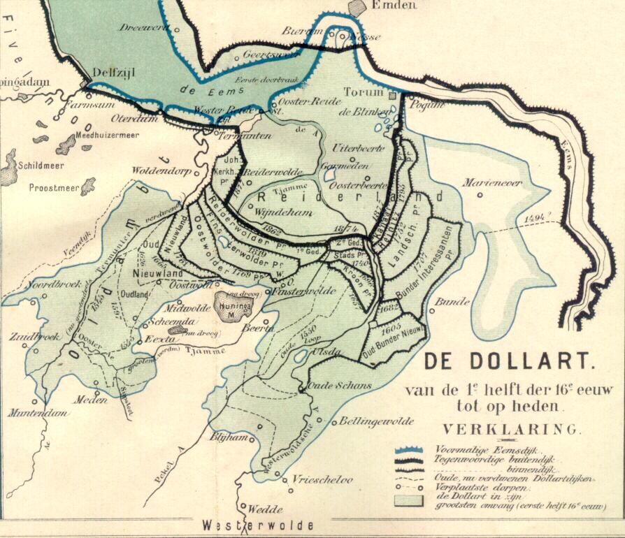
Everybody probably knows about the southwest delta – the delta where in 1953 a big flood hit the Netherlands, and the region where the Delta Works have been constructed. But we have another delta, the Ems delta, in the northeast of the country, covering the province of Groningen. To be more precise, the region can be classified as a Dutch-German delta, because a large part of the estuary lies in Germany, and the river Ems that flows into the estuary comes from there as well. The Dollard is a kind of spatial depression or delta lake in open connection to the Ems, which is characterized by a century long history of settlements, land reclamation, coastal flood disasters and flooding. Over time, lands have been reclaimed and lost again (including settlements) to the sea several times.

  klik voor vergroting
in nieuw scherm   
(source: http://www.weikopiebes.nl/ and http://en.wikipedia.org/

De Graanrepubliek deals with developments in agricultural polders bordering the Dollard. Those polders are typical ‘delta polders’ in the sense that the soils are extremely fertile, supporting the most productive farms of the Netherlands at the time. The farmers produced wheat – of similar importance as rice in food production and consumption in the Asian deltas. The period after the 1960s was socio-economically very dynamic: it was a time when discussions arose about the relation between farmer workers, and the large farmer landowners that got rich by producing wheat, the socio-political tensions that this brought, the interest in socialism, mechanisation in agriculture, and the unification of Europe.

All these developments contributed to what I study in my research: the flooding, or de-poldering, of delta polders. The book describes how European agricultural policy in the 1960s and 70s led to a huge overproduction of wheat. Realizing that maintaining what in fact was a highly subsidized agricultural production system, the Dutch Sicco Mansholt (who was actually born in Groningen, the Ems delta), vice minister of for agriculture in Europe, reduced the formerly ‘guaranteed’ price that would be paid to farmers for their wheat.

The farmers in the Ems delta felt the consequences. Farming wheat became much less profitable, and new plans that were in favour of continued support for agriculture did not pass through the political system. Instead, environmentalists and spatial planners got enthusiastic about other uses of the delta landscape. Instead of farming, which was said to be unprofitable, bad for the environment because of its use of fertilizers and massive wheat production, those social groups wanted the plan ‘Blauwe Stad’ (Blue City).


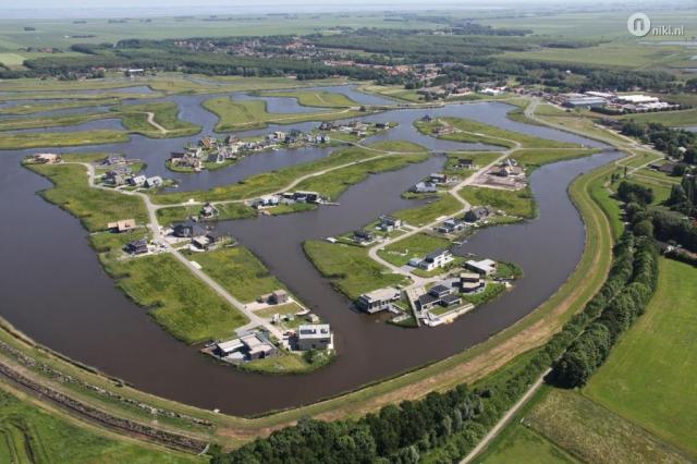
                                                                                  (Source: https://klaasantonmulder.wordpress.com)

Plan Blauwe Stad wanted to flood some agricultural polders in the delta and construct villages around a newly formed delta lake. It was envisaged that many, especially rich city dwellers would favour a house in such an area, with new nature and options for recreation, all supported by a large water body covering some of the most fertile delta soils in the Netherlands. This would stimulate a different type of economic activity in the region: no more agriculture, but delta leisure. A long story short – the plan was accepted  and in 2005 about 1200ha agricultural land was converted into 400ha of new nature and 800ha of water (lake Oldambt).

Now, several years later, Frank Westerman explains in an added chapter that those expectations did not materialize. Only a very small percentage of the plots has been sold, and the province has let go the original plan. It is now presented as a nature development plan with some supportive economic activities and the task to act as a water storage basin in times of high rainfall or river discharge.

All in all a very fascinating story. A typical delta story: dynamics at the border of land and water, times of land (reclamation), of disasters (1877), and since recently also of intentional flooding. But first, it’s time to prepare for a next delta tour up north, to take a first-hand look!

Monday, 3 November 2014

Governance of ‘long term delta planning’ in Bangladesh, Vietnam and the Netherlands

Governance of ‘long term delta planning’ in Bangladesh, Vietnam and the Netherlands
The Deltas in Times of Climate Change Conference II, taking place in September 2014, Rotterdam, presented a suitable occasion to discuss both delta challenges and interesting approaches to how ‘delta dynamics’ are being dealt with worldwide. Delta dynamics include here both environmental (including climatic) and socio-economic processes, and since relatively recent ‘long term delta planning’ is taking shape as an approach addressing these in an integrated manner. The long term delta planning projects taking shape in, amongst other deltas, Bangladesh, Vietnam (Mekong) and the Netherlands, bring up highly relevant (water) governance questions. During the conference’s ‘Bangladesh Delta Session’, centered around the Bangladesh Delta Plan 2100 project, two particular issues were discussed: first, how the BDP2100 works towards practical implementation of the long term vision, and second, which lessons learned in the field of institutional coordination and stakeholder participation can be drawn from delta planning in Vietnam and the Netherlands. Representatives from the three countries, all heavily involved in long term delta planning projects in their respective deltas, presented the state of affairs of the delta plan initiatives and shared their views.

Three long term delta planning cases selected
Noting that in all three countries long term delta plans have been developed earlier, in recent history, new initiatives materialized in the form of the Bangladesh Delta Plan 2100, the Mekong Delta Plan and the Dutch Delta Programme. These initiatives have picked up the challenge of grasping delta developments in the broadest sense, and are trying to come up with both long term delta visions and pathways towards sustainable futures.

The delta planning projects have now been on-going for a number of years, and this ‘phasing’, expressed by the number of years of experiences with long term delta planning, was an important reason to include the three deltas in the discussion. Besides this, the selection was based on the inherent dynamics in each of the deltas. Such dynamics, which include environmental processes (erosion, sedimentation, water flows and flooding, and climate variability), and socio-economic processes (urbanization, migration, rapid increase in economic activity), are materializing at different speeds in the three deltas.


Bangladesh
Vietnam (Mekong)
The Netherlands
‘Phasing’ or number of years of experience with long term delta planning
3 years: 2012 (Feasibility study); 2013 – on-going (Bangladesh Delta Plan 2100)
5 years: 2010 – 2013 (start up and Mekong Delta Plan), 2014 focus on implementation
7 years: 2008 (Working together with Water); 2010 – 2014 (Delta Programme)
Contrasting environmental ‘delta dynamics'
Highly dynamic system, eg regular and extensive floods
Moderately dynamic system, eg regular floods
Relatively stable, eg rarely floods


Apart from those differences the Asian delta plans have in common that they are to a large extent inspired by the Dutch Delta Programme. This is demonstrated by the resemblance in terms of project objective, activities and supporting ‘tools’: the use of scenarios to outline and compare possible measures, explicit attention to uncertainty in decision-making and adaptive delta management as an overarching conceptual model. Some of these ideas are by hindsight captured in the framework of a ‘delta approach’ which was also put forward during the conference. Several renowned Dutch individuals and organizations are involved in the projects in Bangladesh and Vietnam.

Bangladesh: moving from visionary plans to reality…
With the launch of each ‘long term delta plan’ project, the question arises how to ultimately move from a visionary, attractively illustrated plan on paper, to the reality of programme financing and implementation on the ground. In the case of the Bangladesh Delta Plan, the institutional anchorage of the project lies with the same governmental institute that develops national investment plans: the Planning Commission formulates the so-called Five Year Plans. In this way, a cross-cutting institute, as opposed to a project being embedded in one particular ministry, has the ability to reach out to the numerous involved institutions, stimulate inter-ministerial collaboration, and to link long term vision development with (initially, five year) investment plans. Discussions are currently on-going between BDP2100 and the Planning Commission regarding the integration of BDP2100 activities in the 7th Five Year Plan (2016 – 2020), which will be delivered next year. This exchange pursues that recommended no-regret measures will link to investment agendas, and materialize on the ground in the form of concrete projects.

… and synchronizing with on-going initiatives
From another perspective, already existing programmes, formulated by other actors, are being implemented while the long term vision is being developed. This became particularly apparent in the reality of hydraulic interventions in the southwest delta and ‘polder region’ of Bangladesh. The coastal zone is characterized as a highly vulnerable region, due to low-lying land, the occurrence of cyclones, floods and erosion, and a high population density. At the same time it is home to the Sundarbans, the largest mangrove ecosystem in the world in connection to India, acting as a ‘coastal green belt’ reducing the impacts of cyclones. Several initiatives have targeted the southwest delta as a region for continued investments in the water and agricultural production systems at field level. Besides the BDP2100 (approaching the region as one of the ‘hotspot’ areas), the Dutch Embassy in Dhaka (the Blue Gold polder development programme) and the World Bank (the Coastal Embankment Improvement Project) have recently launched large scale water management programmes.  Different ideas about polders, delta dynamics and long term delta planning all converge here, and it remains to be seen how to synchronize these parallel initiatives.

Insights Vietnam and the Netherlands: institutional coordination and stakeholder participation
During the session, questions were raised about who ultimately ‘governs’ the delta plan – is this a collective task of a wider project community, or should a Delta Commissioner be appointed to oversee all? In the Netherlands, the position of a Delta Commissioner was designed as having no particular ministerial affiliation. This was, however, no easy choice and debated heavily from the start. In the case of the Mekong Delta Plan, a regional steering committee was installed to guide the project. It was put forward that there should be not only a Delta Commissioner that takes the Mekong Delta Plan further, but also a Red River Delta Commissioner, to pull off a simultaneous development in the Red River delta, where the Vietnamese central government is located.

Involving the broader ‘delta societies’, beyond the project consortium and partners, was brought forward as an important aspect of long term delta planning. In case of the Mekong Delta Plan, it was raised that public involvement came rather late in the process, and that more attention should go to interaction with especially the businesses community, which is growing in importance in shaping delta activities. This discussion came back in the challenging question raised by a representative of a Bangladesh NGO about ‘which percentage of BDP2100 focuses on engineering, and which percentage on social affairs’ – of course, a very difficult question to answer, but the message was clear: emphasize the need of ownership of the plan with the people well on time.

Concluding remarks
What became clear from the session is that there is a huge scope for continued intra-delta comparison and exchange of experiences, especially because long term delta planning centres around a number of similar principles, approaches and ‘tools’. Although these could themselves be the object of closer scrutiny, long term delta planners in the different countries may be confronted by questions and dilemmas that have been dealt with earlier by their colleagues. This also concerns some of the (water) governance themes as discussed above. Being aware, however, that deltas differ enormously in terms of its environmental and socio-economic dynamics, is important to avoid that a blueprint approach to long term delta planning is being followed.

Monday, 13 October 2014

Delta dolphins

Dolphins have been spotted along the Dutch coast, something that had not happened for a long, long time. According to this website, dolphins disappeared from the Dutch delta after the closure dam in the Zuiderzee was constructed in 1932 and only after some accidental events in the 1940s and 2004, it took until now that the dolphins 'returned'. They were spotted near the southwest delta, close to the Westerschelde.

This is not some small fact, only of relevance to biologist or environmentalists. No - this means that the last piece of the puzzle has been found (and fits)! Because now, the Dutch delta finds itself among the ranks of a number of other dolphin-rich deltas: from the Amazon to the Irrawaddy, but mainly from the Ganges to the Mekong: the two other cases in our comparative research program.

A nice account of a researcher's interest in delta dolphins, something that made me actually notice the importance of the rediscovery of Dutch delta dolphins, is the novel written by Amitav Ghosh, the Hungry Tide. He describes the experiences of a researcher trying to locate the Irrawaddy dolphin, which is the name given to dolphins living in the estuarine environment in Southeast Asia, in the Sumdarbans of the Ganges. In his book, dolphins in the Ganges delta are the central figures around which the delta stories are told.

He describes the dolphin as a species that 'knows' how to deal with the tidal dynamics, both with ebb and high water, and both with fresh and saline water. At the same time it is put under pressure by human settlement in deltas. Traditional knowledge and 'hard science' come together when trying to discover the animals' habits. For many environmental protectionist, the dolphin is an 'indicator' of healthy and good functioning delta ecosystems; for others, a source of spiritual guidance; and for again others, of very little relevance and only a means to reach other ends.

Just to complete this theme - besides the Irriwaddy dolphin (orcealla brevirostris), Bangladesh is also home to the South Asian river dolphin (platanista gangetica): a much smaller cousin, living more (up to hundreds of kilometers inland, even in Nepal), with the habit of swimming sideways. In that way, the dolphin finds its way by touching the ground with one of its fins as a reference, because it can't see well.

Go, Flipper!

Presentation and Louise Fresco's statement on controlled flooding

Last month I had the opportunity to deliver a research presentation to the Wageningen UR Board of Directors. I immediately have to say that this opportunity arose not based on a first hand invitation, but because someone got ill and the organizers needed an alternative pitch - nevertheless, a great occasion to promote a number of research themes and trends in delta I'm working on!

The meeting was with a number of representatives of the Social Sciences Group as part of an 'introduction tour' of the new president of the board, Louise Fresco. Of course, most of you know that she has been one of the members of the 2008 Delta Committee and that initiated at least a few remarks, following the presentation. The link to the slides on Slideshare can be found here.

After the meeting I got in touch with mrs Fresco and she was willing to come up with a statement on controlled flooding: "In The Netherlands, a densely populated country with to two thirds of the inhabitants below sea level, we consider ourselves a living laboratory where infrastructure and a better understanding of controlled flooding coupled with a broad dialogue with society leads to a longtime approach of the challenge of living in an active delta." This would very helpful as a Statement of Support, for next research proposals on the topic!

Wednesday, 1 October 2014

rearviewmirror

I've just spent way too much time looking at the historical maps that are made available here: http://zldgwb.zeeland.nl/gw411sl/?Viewer=Cultuur%20Historie. Our project, and this blog, is called Dynamic Deltas. After visits to the Deltas of Bangladesh and the Mekong in Vietnam I often wondered if the designations 'dynamic' at all applied to the Dutch Delta. Strolling through times and locations on this website makes me realize it most certainly does, or maybe i should say, until the Delta works came in to the picture, it did. Below the growing together of the islands Tholen and st. Philipsland.

 1650

 1916

 1959

2014